In August 2025, the African Union called on the international community to move away from the widely used Mercator projection and adopt the Equal Earth projection, which represents the true relative size of Africa more accurately. The statement aimed to reshape perceptions of Africa and address bias in education, media, and policy.
Why Mercator Is Controversial
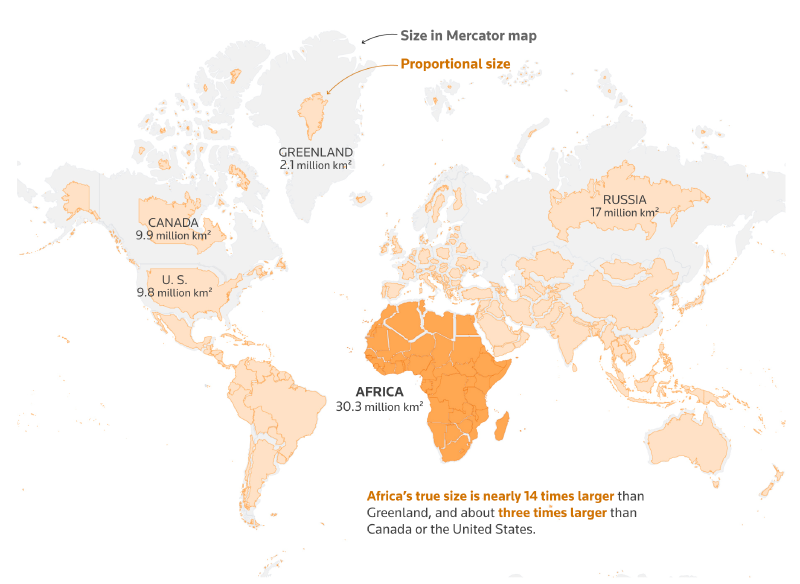
The Mercator projection was created for navigation. It preserves angles, which made it useful for plotting courses at sea. But it greatly exaggerates areas near the poles. Greenland, northern Europe, Russia, and Canada appear much larger relative to equatorial regions than they are on the globe.
Africa is especially affected by this distortion. It is far larger than many people intuitively imagine from standard classroom maps, but Mercator maps make it appear smaller relative to northern countries.
Equal Earth as an Alternative
Equal Earth is an equal-area projection. It preserves relative area, making continents and countries visually comparable by size. It does not preserve shape as Mercator does, but it better supports discussions about geographic scale, population, resources, and global inequality.
Why This Is a Visualization Issue
Map projections are not neutral design choices. They shape mental models of the world. If a projection repeatedly exaggerates some regions and reduces others, it can affect how people imagine importance, distance, and power.
The call to change maps is therefore not only a technical cartographic recommendation. It is also a media, education, and representation issue.
Design Lessons
- Choose projections according to purpose.
- Do not use Mercator as a default world map when area comparison matters.
- Explain projection trade-offs when the map is used for education or policy.
- Consider equal-area projections for global thematic maps.
Summary
The African Union’s call highlights a fundamental point in cartography: every projection makes a choice. Mercator remains useful for certain navigation and web-map contexts, but it is poorly suited to showing the relative size of continents. Equal-area projections such as Equal Earth are better choices when the message depends on geographic scale.