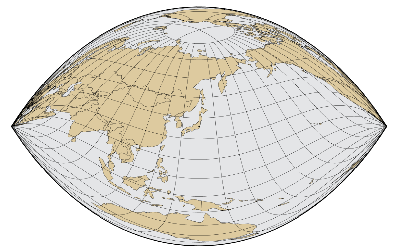
The Craig projection is a map projection devised in 1909 by the British cartographer James Ireland Craig. It belongs to a special category called retroazimuthal projections: from any point on the map, the direction toward a specified reference point is shown correctly.
In other words, if a reference point is chosen, the map is designed so that the bearing from any location on the map to that point corresponds to the real bearing on the Earth.
Historical Background
The Craig projection is often discussed in relation to the practical need to know the direction of Mecca. A retroazimuthal projection can show the direction toward a chosen point from everywhere on the map, which gives it a distinctive purpose compared with more common world map projections.
Unlike projections optimized primarily for area, shape, or navigation, the Craig projection is centered on directional information toward a target.
How It Works
Most map projections choose a balance among distortions in area, shape, distance, and direction. The Craig projection makes a different promise: preserve the direction to one reference point from all other points.
This does not mean all directions are correct. It means the direction to the chosen point is correct. That narrow but powerful constraint gives the projection its unique character.
How to Read It
When looking at a Craig projection, first identify the reference point. The value of the map comes from reading bearings toward that point. The shapes of continents and oceans may look unfamiliar because shape preservation is not the main design goal.
Use Cases
- Showing direction toward Mecca
- Teaching projection trade-offs
- Demonstrating retroazimuthal geometry
- Data visualization examples where a specific destination or center matters
Design Notes
- Clearly mark the reference point.
- Explain that the projection preserves direction only toward that point.
- Avoid using it for area comparison.
- Use it as a focused explanatory projection rather than a general-purpose world map.
Summary
The Craig projection is not a minor variation of ordinary world maps. It is a projection built around a specific question: from anywhere on Earth, which way is a chosen point? Its religious and navigational practicality, combined with its mathematical elegance, makes it a useful example for understanding how map projections encode purpose.